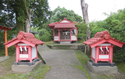
Ame-no-Minakanushi Shrine
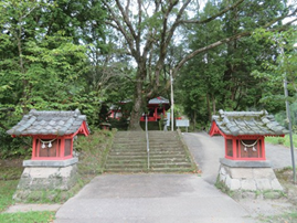
This is located in Kiyomizu Deshimaru. According to the “Shrine Description Book,” it was built in the first year of the Kanko era (1004). It has long been revered as the general guardian of Kiyomizu and is affectionately called “Hosshin-saa.” The deities are Ame-no-minakanushi-no-mikoto, Oohime-no-mikoto, Tsukuyomi-no-mikoto, Izanagi-no-Mikoto, and Izanami-no-mikoto.
The Polar Star is called Myoken Bosatsu (bodhisattva ) in Buddhism and was also an important star deity in Taoism and Onmyodo (Way of Ying and Yang). Since the Middle Ages, Kyoken Bosatsu has been worshiped by warriors as a deity of archery, and Myoken-gu was also invoked as a Shinto deity in Buddhism. The Buddhist name was avoided after the abolition of Buddhism in the early Meiji period (1868-1912), and the shrine was renamed Ame-no-Minakanushi Shrine instead, superimposed on the deity Ame-no-Minakanushi-no-Kami.
According to the “Jinja-shi (Shrine Journal),” the place of prayer was Daimyo-ji Temple. The main hall is located two blocks north of the shrine, Bishamonten (Vaisravana), in Morikida. There is a sacred rock with seven noses at the site of the shrine, which is said to be the tip of the Big Dipper. In addition, offerings are made to the Shioi River, located in the direction of the Tatsumi (southeast) from the shrine’s treasure hall, and sacred objects and sake are offered to the water deity. It is reported in the Local History of Kokubu that this spring is the origin of the place name “Kiyomizu.”
According to “Sangoku Meisho Zue,” a munefuda dedicated by Honda-Inaba-no-kami Chikakane, the lord of Kiyomizu Castle, and Shigetatsu in the second year of the Taiei era, and the regular festival was held eight times a year. The shrine priest in the late Edo period was from the Taniguchi clan, whose ancestor, Taniguchi Awaosuke Nyudo Jinko, made an itinerant pilgrimage to more than 60 provinces throughout Japan from the first to the ninth year of the Tenmon era, offering the Lotus Sutra at various places and praying for the nation’s well-being.
According to Yoshitsugu Hamada, the shrine’s chief priest, until recently, the March 1 Prayer Festival included the dedication and sale of “futsunodago,” a kind of yomogi dumpling, and the festival was attended by many worshippers who came for this purpose. The “Yomogi-kai,” a group of local women, would make the dumplings, but this has been discontinued due to the aging of the local population, among other reasons.
The “okudari” ceremony, held on the third Sunday in July, is still actively practiced today. The procession takes one day to visit 15 different “otabisho” (pilgrimage sites) within the shrine’s parish, with priests, portable shrines, drummers, flag bearers, etc. Before the war, the shrine was also worshiped as a military fortune and longevity deity. Many worshippers came from the Kajiki and Hamanoichi areas. It is said that they would put a charm purchased at that time from the shrine in an iron helmet and take it to the battlefield.
Minakata Shrine
This shrine is located in Deshimaru Uto. The deities are believed to be Takeminakata-no-Mikoto and Amateruhime-no-Mikoto. According to “Sangoku Meisho Zue,” the Honda clan, the lord of Kiyomizu Castle, constructed the shrine. In contrast, the Taniguchi clan was the shrine priest in the late Edo period. It is said that a wooden statue of the deity wearing a robe and a sash is hallowed as the sacred body of the shrine. Its founding date is unknown, but it was once revered as Suwa Shrine or Suwa Daimyojin. Still, the name was changed to its current one after the Meiji Restoration.
It is said that there used to be a munefuda dedicated on the auspicious day of the fourth month in the 13th year of Eisho. At that time, substantial camphor trees lined the shrine building’s left side, creating a solemn atmosphere in its precincts. The shrine also had a graphic tablet of famous poets hanging in the shrine pavilion, but this has been lost. The painted panels are said to have been dedicated to Shimazu Mochihisa and Akihisa in hopes of their long military careers and the prosperity of their descendants (from Local History of Kiyomizu-mura).
Ruins of Ryogon-ji Temple
The family temple of Kiyomizu Township, the Soto sect’s Butsudosan Ryogon-ji Temple, was abolished in the early Meiji period (1868-1912) when the Japanese government abolished Buddhism. Today, the cemetery on the land adjacent to Kiyomizu Danchi is a reminder of those days. According to the “Sangoku Meisho zue,” it is a branch temple of Jigenji Temple in Echizen Province. The temple’s main image is that of Shaka Nyorai. During the Ouei era (1394-1428), Honda-Inabano-kami Chikaharu, the lord of Kiyomizu Castle, invited Zen master Jisei from Oshu to establish the temple. When the temple was founded, it was called Sosho-ji Temple. Still, it was renamed Ryogon-ji Temple by the second abbot, Kido.
After Shimazu Tadayoshi and Takahisa attacked Kiyomizu Castle in 1548 and banished Honda Shigechika, Shimazu Tadamasa came to worship at this temple. When Shimazu Tadamasa was killed in the Battle of Mawari Castle in Fukuyama in 1561, he was buried at this temple, which became his family temple. The cemetery is believed to have contained dozens of graves of Shimazu Tadamasa, his supporters who died in battle, and those of his grandson Akihisa and his wife, Nankun.
However, the cemetery was blown up by an American air raid at about 11:30 a.m. on April 26, 1945.
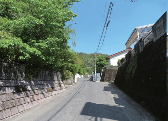
Kiyomizu Castle Ruins
The highest point of Kiyomizu Castle is 182 m above sea level, and the castle area is 900 m at maximum from east to west and 600 m from north to south. The castle is located on the fused and unfused parts of the Ito pumice flow, making entering challenging as the main building is on a cliff. To the east is a series of mountains around 130 m in height, and toward the northeast are the valleys of Rokugo and Kansawatsu. To the west are the ruins of the residence of Shimazu Tadamasa, who was also the lord of the castle and the home of the samurai families known as Kiyomizu fumoto during the Edo period.
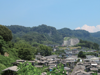
According to “Sangoku Meisho Zue,” the first lord of the castle was Honda Sadachika, who was shugodai (acting military governor) for Shimazu Tadahisa. Sadachika was also the Shugodai of Osumi Province. Kiyomizu Castle is said to have been positioned as his base of operations. Later, in the middle of the Kamakura period, the Saijo clan, who were local government officials, appeared to have made this area their base of operations.
In Eiwa 3 (1377), Shimazu Ujihisa, the governor of Osumi Province, attacked the Saijo clan, and Kiyomizu Castle was entrusted to Ujihisa’s vassals, father and son, Honda Ujichika and Chikaharu.
In May 1548 (Tenbun 17), Kiyomizu Castle, which had been the residence of the Honda clan, was taken over by Shimazu Takahisa and his father, Tadayoshi, and Takashisa’s younger brother, Tadamasa, requisitioned the castle. In October 1548 (Tenbun 17), Shimazu Takahisa entered Kiyomizu Castle. The Jesuit Francis Xavier landed in Kagoshima in July of the following year. He met with Takahisa to obtain permission for Christian missionary work. Some believe that the meeting took place at Kiyomizu Castle.
In 1561 (Eiroku 4), Shimazu Tadamasa, the lord of Kiyomizu Castle, went to Mawari Castle (Fukuyama-cho, Kirishima-shi) with his nephew Yoshihisa to fight against the Kimotsuki clan. He died on July 12 in the battle of Umadachi Jin. Tadamasa’s time at Kiyomizu Castle lasted approximately 13 years, and even today, the location of his mansion is known from Yachi of Kiyomizu Castle’s fumoto to Byodo-ji Temple in Daisen.
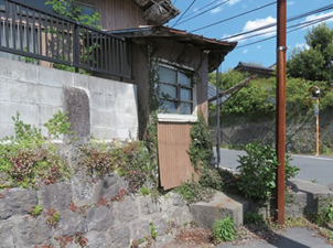
The Ruins of the Temporary House of the Head of Kiyomizu-go
In the Edo period, Kiyomizu-go, which means Kiyomizu Outer Castle, consisted of five villages: Deshimaru, Korida, Yamanoro, Kawahara, and Himegi. Within the Kagoshima domain, 113 outer castles were eventually established. The areas adjacent to Kiyomizu-go included Kokubun-go, Shikine-go, Fukuyama-go, Soo-gun-go, and Hinatayama-go.
An outer castle in the domain under direct Shogunate rule would have a temporary house for the head of the township. According to the Local History of Kiyomizu-mura, the quick house gate, which was the entrance to the temporary home, had a prestigious shape. Even if one passed through the gate, one needed help to go straight to the quick house building as there were an inner gate and wicket. Also seen near the temporary house gate is a “saltpeter hut” with a tiled roof for storing saltpeter, the ingredient of gunpowder.
The book also mentions a back entrance on the east side of the temporary house and that the area is lined with storehouses, grain stores, and stables. It further reports an archery range on the northwest side of the quick house building. It is a valuable historical document that shows where Kiyomizu samurais performed their duties during the Edo period.
Jito (the local headman) was in charge of the administration and military affairs of the outer castle; in some areas, the local headman could be stationed in a particular region, but this was not the case, Kiyomizu-go. Therefore, the actual administration of the township was carried out by the three local officials, atsukai (goshi toshiyori), kumigashira, and yokome, who were elected by the resident tojo shuchu (goshi ).
Kiyomizu Old Post Office
When the postal system was launched in the Meiji Era, it was the local masters who supported the spread of the system. They were appointed mail handlers and performed their duties in exchange for donating their land and buildings.
Kiyomizu Fumoto (Samurai Houses)
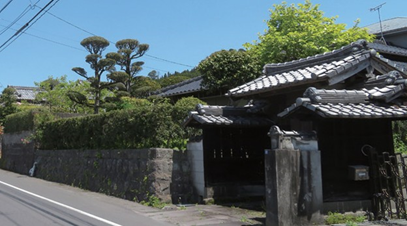
The residential areas of the samurai families became concentrated in the community and were called fumoto. The Kiyomizu fumotos are Shinden Baba, Hasaka, Genkian, Oyama, Byodo, Terababa, Muta, Uchibaba, Toyonokuchi, Kitasako, and Yasudaguchi in Deshimaru-mura. Goushi also resided in Wada, Sakaue, Ochimizu, and Shakada in Yamanoji-mura. They were divided into areas such as shikoji, and dead ends called “sakinashi-no-tokoro” or “masugata” were set up at critical points.
The “Sakinashi-no-tokoro” were Byodo-Baba, Toyonokuchi, Sodokuchi, Ochimizu-guchi, and Genki-guchi, and the masugata were the corners of the residences of Kanzaki-Riemon, Akatsuka-Kiemon, Oyama-Manzenkata, and Shibahara-Gorozaemon.In addition, the takafuda (bulletin board) was used to communicate essential matters in the domain and was located in Toyonokuchi. Furthermore, the swampy lands in the Kijimuta area were considered strategically important.
According to the Miscellaneous Collection of the Old Records, in 1636 (Kanei 13), the Kiyomizu-shu numbered 1,876 men, including 1,082 males, 69 guns, 19 bows, and 32 spears. In 1639 (Kanei 16), the shuchu revenue was about 780 koku. Of this, 19 koku was for the temples and shrines. The number of shuchu was 119, and there were 116 chigyodori. Two families were earning more than 30 koku. In 1713 (Shotoku 3), the revenue held by the Kiyomizu-go was 5,715 koku, and that of shuchu was 665 koku. The total number of shuchu was 742, the number of samurais was 144, and 368 were employees.
Ishi-santou (Sekkannto) in Tsurumaru-don-no-baba
The main stable at the fumoto, “Tsurumaru-don-no-Baba,” is thought to have originated from the location of the Tsurumaru family of fumoto goshi, and there is a masugata at the northern end. At the end of this stable is a “sekkanto,” often found at three-way junctions in southern Kyushu to Okinawa regions.
Most are around 30 cm high and 130 cm long. This also conveys the transition of time, with the lower part integrated with the stone wall and the upper part combined with the concrete.
An unusual feature is that the upper and lower parts are engraved with the words “Ishi santou.” Judging from the degree of carving, the upper part is considered older. According to a resident of the former Yasuda Shoten located behind the Ishi santo, it was damaged during an air raid in the Pacific War. A time bomb exploded near the end of the street and damaged the surrounding area. The stone wall was later restored together with Ishi santo. This means that the letters at the bottom were added after the war.
The upper part’s construction date is precise: November 1740 (Genbun 5). It is believed to be the second oldest in the prefecture.
The Site of Kiyomizu-mura Town Hall
Kiyomizu-mura was established in April 1889 (Meiji 22) with the implementation of the municipality system, and the village council elected the village mayor and assistant mayor. The first village mayor was Wakamatsu Yusuke, the assistant mayor was Kisaki Shigeru, and the village assembly chairman was Kisaki Sukezaemon. Later, in April 1947 (Showa 22), the Local Autonomy Law was promulgated, and the residents elected mayors of municipalities directly. At that time, the neighboring villages of Higashisonoyam and Kirishima were separated, and the boundary of Kiyomizu-mura changed accordingly. With the permission of the Minister of Home Affairs, Maehata, Ikeda, Karuishida, Kawakami, Nanamagarizako, Kitatashiro, and Minamitashiro in Shigehisa, Kirishima-mura were incorporated into Kiyomizu-mura, resulting in ten households with a population of 63 and an area of 8 cho and 8 tannbu at that time. Subsequently, the merger of Kiyomizu-mura with Kokubu-cho and Higashisonoyama-mura was discussed, and a part of Ooaza-Himegi in Kiyomizu-mura was to be merged into Hayato-cho. This is due to the strong demand from locals regarding transportation, economics, and schools. Later, in April 1954 (Showa 29), Kiyomizu-mura was merged, ceased to exist, and became Kokubu-cho. Today, only the gateposts remain where the town hall was located.
Deshimaru Tameike (Reservoir)
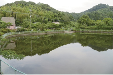
According to the Local History of Kiyomizu-mura, the reservoir area was 3 tan 9 une 6 bu, and the irrigated area was 84 tcho 1 une 2 bu. The date of the first installation is still being determined. Still, the reservoir is believed to be dredged as needed during the domain-rule period. However, when Sakurajima exploded in 1914 (Taisho 3), ash fell and buried the reservoir, making it impossible to use for irrigation. In 1932 (Showa 7), with the help of government subsidies, construction began on December 21, 1932. It was completed on April 1 of the following year.
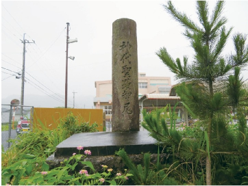
Nyubi-no-oka
A monument is located on the current Kokubu Junior High School grounds. Also known as “Chinoo-oka,” the surrounding environment was significantly changed by the construction of Kokubu Junior High School in 1956 (Showa 31). The Chikao shrine used to be located here and is said to have been founded by Kenbe Munefusa during the Kenkyu era (1190-1199). According to the Local History of Kiyomizu-mura, “Chikao” is derived from “Chiho.” According to the myth, when the deities descended on the peak of Takachiho, a fog was gathering. When seeds of Inachiho were sown, the fog lifted, and the path was opened. The shrine is said to have housed Izanagi-no-Mikoto, the descendant of the deities.